Maricopa County AriZona
Maricopa County AriZona
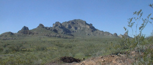
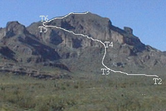
Above: Saddle Mountain from the Northeast.
|
Saddle Mountain is a volcanic upthrust
that contains unique archaeological sites, wildlife
habitat, interpretive geology, and dramatic scenery.
Recognised by travellers for thousands of years, Saddle
Mountain is a distinctive landmark located on the fringe
of metropolitan Phoenix, Arizona--50 miles west of
downtown. The mountain towers 2,000 feet above the
Harquahala Plain at an altitude of 3,037 feet above sea
level.
 Saddle
Mountain and the Palo Verde Hills region share a
history spanning thousands of years of prehistoric
cultures that inhabited the deserts of western arizona.
Three converging washes provided the Palo Verde Hills with
an oasis-like environment. There, Winters Wash funneled
water through the Palo Verde foothills creating lush
stands of mesquite, ironwood, and Palo Verde trees. This
environment provided sources of food and cover. Plus, both
areas offered opportunities for hunting deer and bighorn
sheep along with smaller game animals. An overview of
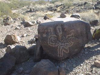
cultures associated with this Saddle Mountain site stretch
from Middle Archaic traditions of the Amargosa and Cochise
to the later Patayan, Hakataya, and Hohokam to more recent
historic Yavapai and lastly, to the historic Anglo
American. Saddle
Mountain and the Palo Verde Hills region share a
history spanning thousands of years of prehistoric
cultures that inhabited the deserts of western arizona.
Three converging washes provided the Palo Verde Hills with
an oasis-like environment. There, Winters Wash funneled
water through the Palo Verde foothills creating lush
stands of mesquite, ironwood, and Palo Verde trees. This
environment provided sources of food and cover. Plus, both
areas offered opportunities for hunting deer and bighorn
sheep along with smaller game animals. An overview of
cultures associated with this Saddle Mountain site stretch
from Middle Archaic traditions of the Amargosa and Cochise
to the later Patayan, Hakataya, and Hohokam to more recent
historic Yavapai and lastly, to the historic Anglo
American.This distinctive landform contains crucial desert bighorn sheep habitat that has been augumented by a water tank developed through the cooperative efforts of the Desert Bighorn Sheep Society, Arizona Game and Fish Department, and the BLM. Lush foliage creates a habitat valuable to a range of wildlife in the Palo Verde Hills, including the desert tortoise and approximately 162 other species. Threatened species within the area include Gila monster, kit fox, cooper hawk, and sharp-shinned hawk. Additionally, prairie falcons and golden eagles are found in the upper reaches of Saddle Mountain. The volcanic upthrust of the mountain has created a highly visual and educational example of geologic forces. Cliffs, spires, and buttes tinted by andesite, rhyolite, and basalt result in magnificent scenery. Another result of Saddle Mountain's complex volcanic history has been 'basketfulls' of colorful minerals scattered the northern skirt of the mountain. However, the once plentiful fire agate, chalcedony, and calcite "desert roses" have now become scarce. The mountain's pyroclastic rocks, distilled by eons of differential erosion, account for the dramatic scenery and multicolored strata that we see today. Complex geology makes Saddle Mountain simply beautiful. --This text from an Arizona Wilderness
Coalition educational handout.
|
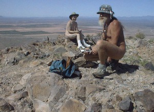
Below L: Camilla and ajo on the summit. Great day for
skinnywalking! (Photo by Bill P.)
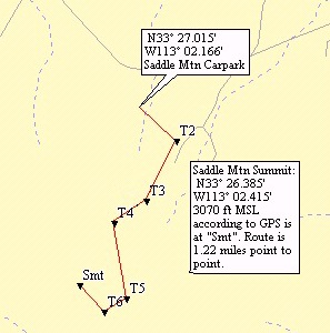
Below Center: GPS waypoints from the carpark south of Courthouse
Road. 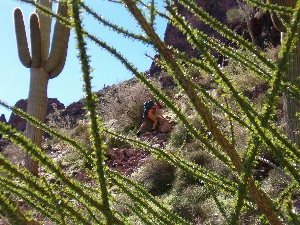
Below R: ajo on the trail near T4. ( Photo by Tom C.)
Saddle Mountain Trail Waypoints (ascending)
Carpark; N33d27.028m, W113d02.167m, 1450f MSL; is the carpark south of Courthouse Road.
T2; N33d26.889m, W113d02.010m; right turn off the trail that traverses the flats between the carpark and the pass of the Pioneer's Monument.
T3; N33d26.679m, W113d02.135m; right turn off this well defined
trail to head more southwesterly and begin climbing steeply. If
you make the turn at the right place you will find faint traces of
trail that pass to the north (right) of a large outcrop of dark
rock.
The well defined trail continues ahead and climbs through a
series of switchbacks to rejoin this trail near T6.
T4; N33d26.603m, W113d02.277m; near the base of the upper cliffs turn left, east of south, and climb the ramp that extends along the base of the cliff. The trail is faint, very rough and slippery, crosses several gullies, and eventually passes below the mouth of a small cave. Continue in this generally east of south direction, always climbing until you pass the south end of the cliff and come to a deep gully.
T5; N33d26.334m, W113d02.222m; turn southwest up into a small hanging valley at the head of the deep gully and work around to the south of the cliff wall. Continue up, and southwest, almost to the top of this col where it ends in a precipitous drop.
T6; N33d26.286m, W113d02.309m; another right turn, to the northwest, climbing steeply over the rubble to a fairly easy, almost level, final approach to the summit. To your left (west) is a sheer drop of a thousand feet. To the right is a steep decline rolling down to the top of the cliff that rises between T4 and T5. Ahead climbs gradually to the summit.
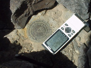
Summit; N33d26.385m, W113d02.415m, 3070 to 3100 according to my measure, 3037 according to the topo map; is indicated by a low stone cairn. Under the top rock is found a cookie tin, and a bench mark placed in 1947. There are two witness marks, a few yards roughly north and south of the summit marker. In the cookie tin is a log book.
The trail is 1.22 miles point to point but probably half again,
maybe twice, as long with all the zigs and zags added in.
Good luck going down...
El Dorado Hot Spring on
Indian School Road in downtown Tonopah AridZona is a great place
for a shower and a soak after your hike; the hot mineral water
does a good job soothing tired muscles and dry skin. They also
offer camping and cabins. Walkins Welcome.
All photos by ajo except the one of Camilla & ajo which is by
Bill Pennington, and the one of ajo alone is by Tom Cowan.
Copyright © 2019, A.J.Oxton, The Cat Drag'd Inn ,
03813-0144. ![]()